
Southern & Central Sierra PCT Weather Update, 5/30/23:
What’s Going on with the Sierra Thaw?
…it’s still in Transition!
Historically, the Sierra Thaw starts around the end of May, or the first of June, depending on the type of winter preceding and other major details, like ambient temperatures, cloud cover, wind, and the arrival of more snow or, even, rain. So, there isn’t a clear-cut, scheduled, and mass-advertised date on the calendar when it happens, meaning one day it’s winter and snowing and the next it is hot as hell, like summer. Weather changes in the mountainous setting can happen that way, but when it comes to seasonal transitions, they’re usually gradual, but noticeable, if you’re watching.
The huge winter of 2022-2023 began early, ran hot and heavy with atmospheric river after atmospheric river, then, surprisingly, the general trend in the Sierra weather started to suddenly warm up! I called it, at the time, akin to Braxton-Hicks’ false-labor contractions in the delivery of a human child. Suddenly, they start, but don’t develop strong enough to birth the baby. So far, this season, only the lower elevations of the Sierra have delivered sufficiently warm weather to birth the baby of Spring; the higher elevations are still holding fast to their layer of deep snow with cool days and sub-freezing nights!
On May 14th, I wrote, “Southern Sierra PCT Weather Update, 5/14/23” in which I declared the Sierra hiking conditions on and along the Pacific Crest and John Muir Trails (to include snowpack stability and dangerous creek crossings) to be as follows,
“Yellow Flag = 11,500-feet and above
Red Flag = 10,000-feet and below”
This meant that the Thaw-inducing, Braxton-Hicks, warming air temperatures were starting to rise up the collective Sierra mountainside from the springtime, San Joaquin Valley, down at sea level, to around the 10,000-foot elevation (making people and the media think that the whole Sierra was going to have a melt-down!) producing a “soup-for-snow” snowpack that’s horrible to try and backpack in and raging, whitewater creeks that want to kill you.
Above 11,000-feet, the air temperatures were still cold enough during the day and sub-freezing at night to allow manageable over-snow hiking without snowshoes.
And, the early reports from NoBo PCT thru-hikers coming out over Bishop Pass confirmed this. The colder it was at night, the longer during the day they could walk on the surface of the snowpack before starting to suddenly sink-in, or “posthole.”
That was a week ago.
With monsoonal moisture coming north from the Gulf of Mexico threatening snowpack-melting rain while a series of cold, Low-Pressure Systems sit off the coast of California spitting lots of clouds, some rain, snow, and thunder/lightning, the Sierra is starting to cool off, again – and this is good news for remaining NoBo PCT thru-hikers! The Sierra Thaw threatened to arrive at “thru-hiker cruising altitude” of 11,300-feet, but didn’t quite pull it off!
This will mean that:
1) Sub-freezing overnight temps will prevail to keep that massive snowpack intact (at that elevation and above) and hard-surfaced enough for easy snow-hiking for the next few weeks (at least for most of the morning hours),
2) Snow bridges that were, once, thick and strong enough to hold a hiker’s weight and allow safe passage over slowly growing creeks during the “Secret Season” are, now, starting to thin and fall down (except at higher elevations), and
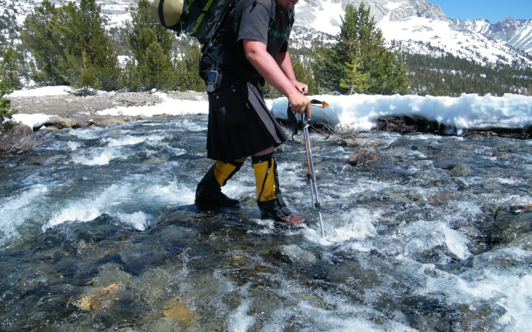
3) The creeks, themselves, at 11,300-feet and above will start “opening-up,” as the snow bridges disappear, and their flow volume and rates will start to increase, making for ever higher risks of successful wet-crossings.
In short,
🥾 Winter was cold and horrible,
🥾We thought that the warm days of Spring were arriving, but that was seen only at low and middle elevations, and
🥾Low-Pressure weather systems bringing cold air and the possibility of snow will continue to spin off the California coast and throw clouds across the Sierra, further delaying the arrival of the Thaw at elevations above 11,000 feet for the next few weeks (into early June).
The “Red Flag of Danger” is still out on the wilderness trail track below 10,000-feet to forewarn hikers about the dangers of high-flow creeks and miserably wet snow-hiking conditions present, there.
The “Yellow Flag of Caution” is still flying over the High Country to make hikers aware of the risks of falling snow bridges, a softening snow surface, the “opening” of creeks, and the slow rising of creek flow rates and volumes as the Thaw approaches over the next 2-3 weeks.
Be advised to the conditions into which you desire to travel and plan accordingly!
Advisory:
As the Thaw approaches, snow-hikers thinking of attempting to navigate the PCT through the northern washboard of Yosemite National Park should refrain and stay away, as the miles-long creeks above the summer trail’s crossing of them will be running dangerously high and fast! These creeks have killed hikers in the past.
I advise everyone to stay away from this region until further notice and keep in mind that it will take months, this year, for these creeks to become safe for fording!
NoBo PCT thru-hikers should skip around this area and restart on Sonora or Echo Passes.