
Ned Walk-2 (7/29/23),
A Walk to Remember:
(Part-2)
In order to know how to recognize where you’re going without even a map, you’ve got to know the lay of the land in your head. If you’re a visual learner, or have what we used to call a photographic memory, that’s probably going to be pretty easy. The main things to know, however, are what landmarks lay ahead and what their identifiable features will be, so you’ll know recognize them when you see them. After that, you should probably know when to expect to see them!
The plan has to be that, if you don’t see the next one when you expect to, everyone stops and looks around to visually retrace the route thus far (to make sure that you didn’t go the wrong way), orients and inspects a detailed topographic map of the area to locate identifiable landmarks nearby (to figure out where you currently are), and from that info, plot a course forward, whichever way that’s going to be.
The second half of “Ned Walk-2” was to share with my three guests that joined me, how to follow a creek drainage without a paper map, compass, or geospatial satellite location device (we have those, these days, that hikers totally rely on to know this stuff and without which they feel lost) for a couple of miles, over lots of intriguing and distracting scenery, to arrive at a headwaters lake (Ralston Lake) without missing a hidden lake along the way! Now, let’s go find our intrepid hikers and see what happens, next!
The easy thing about following a Sierra creek drainage is that it’s usually in a valley with walls! So, as long as you can see them and stay between them, as you walk up the valley floor, you’re good to go – but you’ve gotta see them. That was our immediate problem. The old Boy Scout Camp was completely overgrown in aspens, willows, and pines with very few opportunities to see out and up to the valley walls on either side, so off we went to find “high ground.”
Ascending over randomly strewn angular granite boulders, past little clusters of soft yellow, white, and blue alpine flowers, and up narrow, little swales filled with mini-meadows of grass, rocks, and logs, we finally topped out at…the strewn remains of a destroyed and scattered, concrete and granite building, once complete with a nice, little fireplace, the frame of which was upside-down in the middle of it! Surmising that this must have been the Camp Counselor’s “Eagle’s Nest,” as it conveniently overlooked the entire camp, below, we suddenly had the view we needed to get our visual bearings to continue on.
I have a thing about ruins. I get sympathetic for all the hope, cost, and effort that went into accomplishing the dream of the place to the point where I can barely move. It’s as if I can feel the people who lived there, their joys and sorrows, and I always leave a bit melancholy. So it went, once again, in this ruin, as we all loitered around the small site, poking into clusters of busted-up rock and concrete to see what was there while looking up to enjoy the view up and down the canyon. This camp sure must have been the darling gem of the BSA during the ’50s and ‘60s!
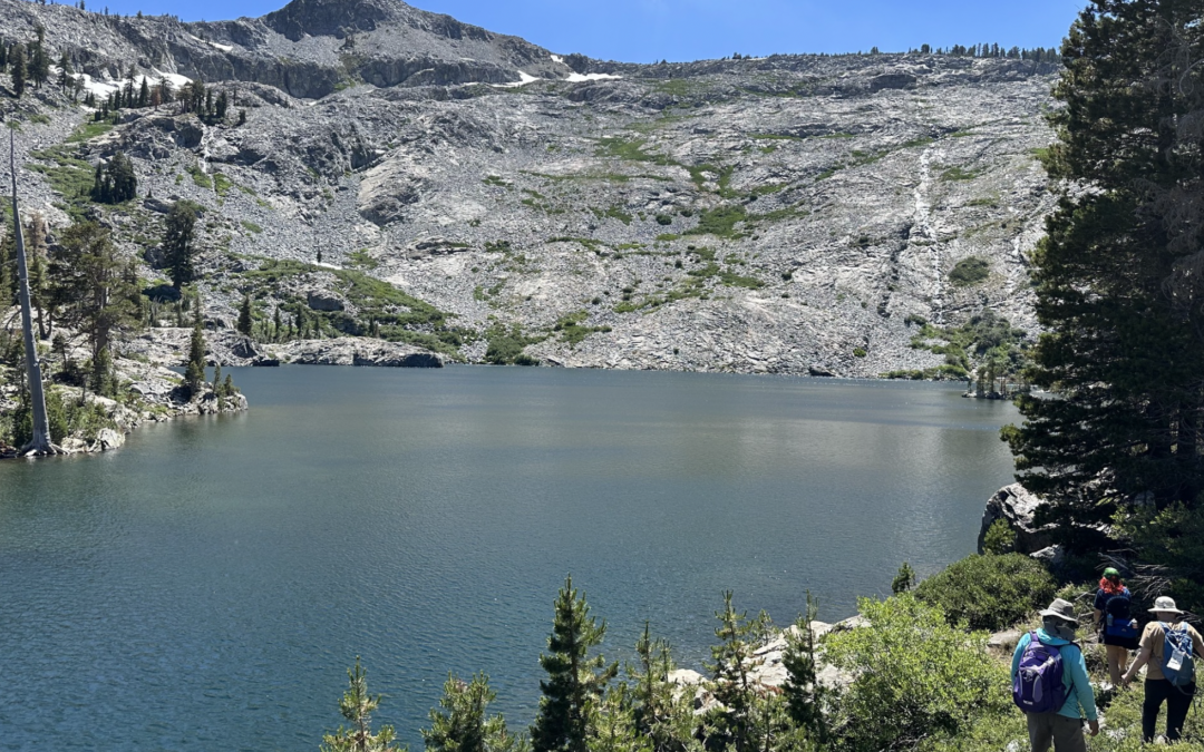
To continue on up the drainage and northbound, there were four landmarks to be identified, two of which we had to stay between (Echo Creek, down below us to the west and the ridgeline to the east that formed a line between Echo Peak and Keiths Dome), another, a terminal moraine that rimmed-in Tamarack Lake, that was to the north, and the last was our destination, Ralston Lake, which was way up and ahead of us to the north-west in a rather large, U-shaped depression.
But, what does a “depression” in the ground look like when everything all around us looks a bit desolate and barren (maybe that’s why the area is called, Desolation Wilderness!)?
Thus, began an explanation on how to “see” the lay of the land around us or, in other words, how to “read” its bumps and folds, peaks, and ridges to know where to go! It became very obvious that we couldn’t get too close to the creek to the west, as the terrain on either side of it “cliffed-out” in precipitous 40-foot drop-offs to the water’s edge (not safe) yet, we didn’t want to stray too far up the canyon wall on our east side, as it got too steep over there, too.
So, we picked our way over log and bush, enjoying more alpine flowers along the way, while following the flatter part of the bottom of the valley and getting ever closer to the wall in front of us that was the terminal moraine of Tamarack Lake.
Now, it helps to know a little history about how the area was originally made! The Lake Tahoe environs were carved-out by glaciers long ago, after plate tectonics uplifted the Sierra Massif and a few volcanoes blew their heads off. Knowing, then, that glaciers make U-shaped valleys, push huge piles of rocks in front of them and disgorge more along their sides during ice ages, then melt and recede back during global warming events forming huge holes in the ground, we walked and talked and tried to visualize these telltale signs.
Knowing that the wall in front of us was the terminal moraine of Tamarack Lake, but beside which, to its west, the outflow of Ralston Lake cascaded into Echo Creek, all we had to do, really, was continue north to the foot of the moraine, turn west, cross Ralston’s outflow, and follow it uphill till we arrived at the lake. So, where was the little mystery lake that we had to find?
[I’m detailing all this to show that with a simple awareness of the local topography, you can move around in it with confidence, as long as you can identify and find your expected landmarks along the way!]
Actually, we nearly fell right into it, since it lay in a fold of granite right before Ralston making it impossible to “see” from below! While scrambling up ever-more strewn granite boulders, we suddenly topped-out on a slight ridge and there it was, little Cagwin Lake and the site of a much-needed break, lunch, and swim!
No trail leads to this lake; not even a “use-trail” made by frequent fishermen or exploring hikers fresh off the Pacific Crest Trail, about a mile to the east. There may have been one or two campsites beside the lake in the denser pines and firs, but they were rough and rudimentary (yet, we all made a “note-to-self” to return because it was quiet, serene, and unpopulated!).
Ralston Lake, an especially beautiful, arrowhead-shaped gem carved into the end of the steep, granite canyon only a quarter of a mile further up, had both a use-trail and people! It was here that one of my guests held fond memories of visiting many years earlier and capturing a photo of the stunning setting with a friend. The last landmark to be reunited with on this trip was a huge boulder sitting beside and above the lake from which that memory of old was immortalized. Thankfully for our tired feet, a lot of other people over the years had felt the same about the view from that rock, such that there was a trail right to it (and roomy campsite nearby)!
As horses commonly wake up and get energetic at the prospect of turning and going “back to the barn” after a long ride, so, too, did all of us on the undulating stroll from Ralston to Tamarack and the final mile back down to the old Boy Scout Camp on Echo and its boat taxi pier, where we caught a ride back to the Echo Chalet trailhead, where we started the day, for ice cream and stories of the Walk’s explorations!
[The next Ned Walk-3 will be held on 8/12/23 and start at 0900 from the PCT-north trailhead and parking lot on Carson Pass, highway 88. They are always free and everyone is welcome to join me as I explore another fun, short trail with a bit of history].